The Future of Africa: How the Continent May Split and Rwanda Could Gain Coastal Access
Imagine waking up one day to find that Rwanda has become a coastal nation, with people from different continents traveling to Gasabo without the need for airplanes or cars, and fishing becoming a major source of national income. Goods would arrive from overseas without passing through Tanzania or Kenya!
You might think this is a dream, but according to Earth science experts, it’s something that will eventually happen, even if it takes millions of years.
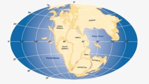
History shows that around 300 million years ago, Earth didn’t have the seven continents we see today. Instead, there was one large landmass called Pangaea, surrounded by a single ocean known as Panthalassa.
The Earth has three layers: the Crust, where we live; the Mantle, made up of hot rocks; and the Core. The continents as we know them today were formed by the Crust breaking into pieces, a process driven by forces from the Mantle below.
To better understand this, think about how the ground cracks after rain dries up. This is similar to what happens to the Earth’s surface, with the continents appearing to “float” on molten rock underneath.
A book titled Ancient Supercontinents and the Paleogeography of Earth by Earth scientists Trond Torsvik, Mathew Domeier, and Robin Cocks shows that Pangaea began to split between 195 and 170 million years ago, during the Jurassic Period, the time of the dinosaurs. The Atlantic Ocean emerged, and new continents formed.
Gondwana, a southern landmass that included today’s Africa, South America, Antarctica, India, and Australia, separated from Laurasia, which included Eurasia and North America. About 150 million years ago, Gondwana broke apart, with India separating from Antarctica, and Africa splitting from South America.
This is why the climates and natural environments of Africa’s northern regions resemble those of southern Europe, and why the southern parts of Angola have similarities with Brazil.
Rwanda Could Gain Coastal Access
Landlocked countries like Rwanda, Uganda, Burundi, DR Congo, Malawi, and Zambia may eventually find themselves bordering a new ocean. This is due to Africa’s gradual splitting into two parts, with the East African Rift System (EARS) separating one side from the other. This process could result in eastern Africa drifting toward the Indian Ocean.
According to Earth scientists, this separation will start in northeastern Africa and extend southward, eventually including Ethiopia, Kenya, DR Congo, Uganda, Rwanda, Burundi, Tanzania, and Malawi, and ending in Mozambique.

Rwandan Senator Emmanuel Havugimana, who is also an expert in Earth sciences, explains that this process has already begun. He notes that the eastern part of Rwanda is moving away from DR Congo at a rate of 3 cm per year, or 3 meters every century. This rift extends from the Red Sea through Ethiopia, down to Lake Kivu, Tanganyika, and Malawi, and ends at the Indian Ocean.
Havugimana estimates that this split may fully occur by the year 2200. The Earth’s surface is made up of nine large tectonic plates floating on molten rock beneath the Crust. These forces are slowly pulling the continent apart.
While no one alive today will witness the final separation, the process is underway, and over time, countries like Rwanda could find themselves with access to the ocean.
How Did It Start?
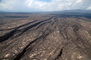
The East African Rift System is believed to have formed about 22 million years ago, but the first major signs of splitting appeared in 2005 when a massive rift opened in the Afar Desert in Ethiopia after the Dabbahu volcano erupted.
Researchers say that this rift involves several tectonic plates, including the Somali Plate (which includes Comoros, Kenya, Madagascar, and Somalia), the Arabian Plate (including Yemen, Oman, Saudi Arabia, and Jordan), and the Nubian Plate (covering the remaining parts of Africa).
In 2018, scientists confirmed the process was ongoing when another crack appeared in Narok, Kenya, after heavy rainfall. The continuing expansion of these rifts supports predictions that eastern Africa will eventually break away from the rest of the continent.
As this happens, Ethiopia, Kenya, and Tanzania could end up with coastlines on both sides, while landlocked nations like Rwanda, Burundi, and DR Congo will gain direct access to the Indian Ocean.
This geological transformation could greatly benefit Rwanda’s economy by eliminating the need to rely on distant ports like Mombasa and Dar es Salaam for trade, reducing transportation costs and time.
Although researchers are unsure if this separation will accelerate, as it did with the split between Africa and South America (now 9,325 kilometers apart), the forces driving Africa’s division are becoming clearer. The process is fueled by “lithospheric buoyancy forces” within the Earth’s lithosphere and by convection currents in the molten rock below.
The Earth’s continents began to break apart during the age of dinosaurs, creatures that weighed between five and seven tons and measured up to 24 meters in length.